Sunday, August 26, 2012

Bunaken National Marine Park, in Manado

Being in the Bunaken Marine Park Bunaken Subdistrict Kel. Bunaken about 7 miles from the Port of Manado which can be taken for 35 minutes from downtown by boat motors. At first Bunaken is a coral island (atoll). It covers an area of about 887.5 hectares with a slightly wavy morphology conditions. Bunaken National Marine Park is one of the most beautiful in the world.

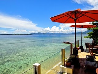
Most of the coastline consists of mangrove forests and white sand. There is a sea of hard and soft coral reefs, coral walls are steep, with various shapes and colors of marine life including fish are sharks, turtles, Mandarin Fish, sea horses, stingrays, and the famous King of the Sea is an ancient fish (Coleacant) and there are many more that make up the beautiful marine park. Beautiful sea garden can be seen in locations called Lekuan 1, 2, and 3, Fukui, Mandolin, Tanjung Paragi, Ron’s Point, Sachiko Point, Pangalisang, Home Village, and East Bunaken. Where tourism and marine tourism Sea tourism visits to the object, the sea and the beach. Tourism activities to do, a way to enjoy the marine park sigtseeing (round) glass boat (catamaran), snorkeling (swim wear breathing apparatus) diving and underwater photography; and sunbathing bodies and beach outings. The facilities provided in the Bunaken marine park, which filled the boat, diving center, cottage (specialty) restaurant, pavilion, and souvenir stalls. Tourism Indonesia Heaven on Earth.

Bunaken National Park is representative of Indonesia’s tropical aquatic ecosystem consisting of mangrove ecosystems, seagrass beds, coral reefs, and land / coastal ecosystems. In the northern part of the island of Bunaken, Manado Tua island, the island Montehage, Siladen island, the island of Nain, Nain Small islands and some coastal areas of Cape Pisok. While in the Southern Cape coast includes some coconut. Potential land islands national park is rich in species of palm, sago, woka, silar and coconut. Animal species that live on the mainland and coastal regions such as Sulawesi black macaques (Macaca nigra nigra), deer (Cervus russa timorensis), and possum (Ailurops ursinus ursinus). plant species in the mangrove Rhizophora Bunaken National Park is sp., Sonneratia sp., Lumnitzera sp., and Bruguiera sp. This forest is rich with various kinds of crabs, shrimp, mollusks and various types of sea birds such as gulls, herons, tern, and cangak sea. Types of algae found in this park include the type of Caulerpa sp., Halimeda sp., And Padina sp. Seagrass Montehage dominated mainly on the island, and islands are Thalassia hemprichii Nain, Enhallus acoroides, and Thalassodendron ciliatum.

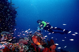
Recorded 13 general living coral in the waters of Bunaken National Park, dominated by fringing reefs and barrier reefs. The most interesting is a vertical cliff as far as 25-50 meters. Approximately 91 species of fish found in waters of Bunaken National Park, including fish gusumi horse (Hippocampus horse), white oci (Seriola rivoliana), lolosi yellow tail (Lutjanus kasmira), goropa (Ephinephelus spilotoceps Pseudanthias hypselosoma), ila trunk (Scolopsis bilineatus) , and others. Types of mollusks like giant clams (Tridacna gigas), head of the goat (Cassis cornuta), hollow nautilus (Nautilus pompillius), and tunikates / ascidian.

The best visiting season: May / August each year. How to reach the location: Bunaken National Park can be reached through the port of Manado, Marina Nusantara Diving Centre (NDC) in the District of Molas and Marina Blue Banter. From Manado harbor by boat motors toward the island can be reached Siladen + 20 minutes + 30 minutes Bunaken island, the island Montehage + 50 minutes and +60 minutes Nain island. From Blue Banter Marina with yachts that are available to the tourist area on Bunaken island can be reached within 10-15 minutes, while the NDC harbor to the dive sites in Bunaken island by speed boat to within + 20 minutes.

Sunday, December 11, 2011

Raja Ampat Islands - Papua


Located off the northwest tip of Bird's Head Peninsula on the island of New Guinea, in Indonesia's West Papua province, Raja Ampat, or the Four Kings, is an archipelago comprising over 1,500 small islands, cays and shoals surrounding the four main islands of Misool, Salawati, Batanta and Waigeo, and the smaller island of Kofiau. Raja Ampat Regency is new regency which separated from Sorong Regency at 2004.[1] It encompasses more than 40,000 km² of land and sea, which also contains Cenderawasih Bay, the largest marine national park in Indonesia. It is a part of the newly named West Papua (province) of Indonesia which was formerly Irian Jaya. The islands are the most northern pieces of land in the Australian continent. The name of Raja Ampat comes from local mythology that tells about a woman who finds seven eggs. Four of the seven eggs hatch and become kings that occupy four of Raja Ampat biggest islands whilst the other three become a ghost, a woman, and a stone.


History shows that Raja Ampat was once a part of Tidore Kingdom, an influential kingdom from Maluku. Yet, after Holland invaded Maluku, it was shortly claimed as a part of the kingdom of Holland. The main occupation for people around this area is fishing since the area is dominated by the sea. They live in a small colony of tribes that spreads around the area. Although traditional culture still strongly exists, they are very welcoming to visitors. Their religion is dominantly Christian.

The oceanic natural resource around Raja Ampat makes it significantly potential as a touristic area. Many sources place Raja Ampat as one of their top ten popular places for diving whilst it becomes number one in terms of underwater biodiversity.

According to Conservation International, marine surveys suggest that the marine life diversity in the Raja Ampat area is the highest recorded on Earth.[2] Diversity is considerably greater than any other area sampled in the Coral Triangle composed of Indonesia, Philippines and Papua New Guinea. The Coral Triangle is the heart of the world's coral reef biodiversity, making Raja Ampat quite possibly the richest coral reef ecosystems in the world.


The area's massive coral colonies along with relatively high sea surface temperatures, also suggest that its reefs may be relatively resistant to threats like coral bleaching and coral disease, which now jeopardize the survival of other coral ecosystems around the world. The Raja Ampat islands are remote and relatively undisturbed by humans.

The high marine diversity in Raja Ampat is strongly influenced by its position between the Indian and Pacific Oceans, as coral and fish larvae are more easily shared between the two oceans. Raja Ampat's coral diversity, resilience, and role as a source for larval dispersal make it a global priority for marine protection.

1,309 fish species, 537 coral species (a remarkable 96% of all scleractinia recorded from Indonesia are likely to occur in these islands and 75% of all species that exist in the world), and 699 mollusk species, the variety of marine life is staggering. [3] Some areas boast enormous schools of fish and regular sightings of sharks, such as wobbegongs.

Although accessing the islands is not that difficult, it takes some time. It takes six hours flight from Jakarta, the capital city of Indonesia to Sorong. Then, taking boat to reach the islands is necessary.

Source :
http://santaisejenak.com
http://id.indonesia.travel/index.php


Bali island

Bali is an Indonesian island located in the westernmost end of the Lesser Sunda Islands, lying between Java to the west and Lombok to the east. It is one of the country's 33 provinces with the provincial capital at Denpasar towards the south of the island (strictly speaking, the province covers a few small neighbouring islands as well as the isle of Bali).
With a population recorded as 3,891,000 in the 2010 census,[2] the island is home to most of Indonesia's small Hindu minority. In the 2000 census about 92.29% of Bali's population adhered to Balinese Hinduism while most of the remainder follow Islam. It is also the largest tourist destination in the country and is renowned for its highly developed arts, including traditional and modern dance, sculpture, painting, leather, metalworking, and music. Bali, a tourist haven for decades, has seen a further surge in tourist numbers in recent years.
Bali was inhabited by about 2000 BC by Austronesian peoples who migrated originally from Taiwan through Maritime Southeast Asia.[3] Culturally and linguistically, the Balinese are thus closely related to the peoples of the Indonesian archipelago, Malaysia, the Philippines, and Oceania.[4] Stone tools dating from this time have been found near the village of Cekik in the island's west.[5]


In ancient Bali, nine Hindu sects existed, namely Pasupata, Bhairawa, Siwa Shidanta, Waisnawa, Bodha, Brahma, Resi, Sora and Ganapatya. Each sect revered a specific deity as its personal Godhead.[6]
Balinese culture was strongly influenced by Indian, Chinese, and particularly Hindu culture, beginning around the 1st century AD. The name Bali dwipa ("Bali island") has been discovered from various inscriptions, including the Blanjong pillar inscription written by Sri Kesari Warmadewa in 914 AD and mentioning "Walidwipa". It was during this time that the complex irrigation system subak was developed to grow rice. Some religious and cultural traditions still in existence today can be traced back to this period. The Hindu Majapahit Empire (1293–1520 AD) on eastern Java founded a Balinesecolony in 1343. When the empire declined, there was an exodus of intellectuals, artists, priests, and musicians from Java to Bali in the 15th century.

Tanah Lot, one of the major temples in Bali
The first European contact with Bali is thought to have been made in 1585 when a Portuguese ship foundered off the Bukit Peninsula and left a few Portuguese in the service of Dewa Agung.[7] In 1597 the Dutch explorer Cornelis de Houtman arrived at Bali and, with the establishment of the Dutch East India Company in 1602, the stage was set for colonial control two and a half centuries later when Dutch control expanded across the Indonesian archipelago throughout the second half of the nineteenth century (see Dutch East Indies). Dutch political and economic control over Bali began in the 1840s on the island's north coast, when the Dutch pitted various distrustful Balinese realms against each other.[8] In the late 1890s, struggles between Balinese kingdoms in the island's south were exploited by the Dutch to increase their control.
The Dutch mounted large naval and ground assaults at the Sanur region in 1906 and were met by the thousands of members of the royal family and their followers who fought against the superior Dutch force in a suicidal puputan defensive assault rather than face the humiliation of surrender.[8]Despite Dutch demands for surrender, an estimated 1,000 Balinese marched to their death against the invaders.[9] In the Dutch intervention in Bali (1908), a similar massacre occurred in the face of a Dutch assault in Klungkung. Afterwards the Dutch governors were able to exercise administrative control over the island, but local control over religion and culture generally remained intact. Dutch rule over Bali came later and was never as well established as in other parts of Indonesia such as Java and Maluku.
In the 1930s, anthropologists Margaret Mead and Gregory Bateson, and artists Miguel Covarrubias and Walter Spies, and musicologist Colin McPheecreated a western image of Bali as "an enchanted land of aesthetes at peace with themselves and nature", and western tourism first developed on the island.[10]

Balinese dancers show for tourists, Ubud.
Imperial Japan occupied Bali during World War II. Bali Island was not originally a target in their Netherlands East Indies Campaign, but as the airfields on Borneo were inoperative due to heavy rains the Imperial Japanese Army decided to occupy Bali, which did not suffer from comparable weather. The island had no regular Royal Netherlands East Indies Army (KNIL) troops. There was only a Native Auxiliary Corps Prajoda (Korps Prajoda) consisting of about 600 native soldiers and several Dutch KNIL officers under command of KNIL Lieutenant Colonel W.P. Roodenburg. On 19 February 1942 the Japanese forces landed near the town of Senoer. The island was quickly captured.[11]
During the Japanese occupation a Balinese military officer, Gusti Ngurah Rai, formed a Balinese 'freedom army'. The lack of institutional changes from the time of Dutch rule however, and the harshness of war requisitions made Japanese rule little better than the Dutch one.[12]


Following Japan's Pacific surrender in August 1945, the Dutch promptly returned to Indonesia, including Bali, immediately to reinstate their pre-war colonial administration. This was resisted by the Balinese rebels now using Japanese weapons. On 20 November 1946, the Battle of Marga was fought in Tabanan in central Bali. Colonel I Gusti Ngurah Rai, by then 29 years old, finally rallied his forces in east Bali at Marga Rana, where they made a suicide attack on the heavily armed Dutch. The Balinese battalion was entirely wiped out, breaking the last thread of Balinese military resistance. In 1946 the Dutch constituted Bali as one of the 13 administrative districts of the newly proclaimed State of East Indonesia, a rival state to the Republic of Indonesia which was proclaimed and headed by Sukarno and Hatta. Bali was included in the "Republic of the United States of Indonesia" when the Netherlands recognised Indonesian independence on 29 December 1949.
The 1963 eruption of Mount Agung killed thousands, created economic havoc and forced many displaced Balinese to be transmigrated to other parts of Indonesia. Mirroring the widening of social divisions across Indonesia in the 1950s and early 1960s, Bali saw conflict between supporters of the traditional caste system, and those rejecting these traditional values. Politically, this was represented by opposing supporters of the Indonesian Communist Party (PKI) and the Indonesian Nationalist Party (PNI), with tensions and ill-feeling further increased by the PKI's land reform programs.[8] An attempted coup in Jakarta was put down by forces led by General Suharto. The army became the dominant power as it instigated a violent anti-communist purge, in which the army blamed the PKI for the coup. Most estimates suggest that at least 500,000 people were killed across Indonesia, with an estimated 80,000 killed in Bali, equivalent to 5% of the island's population.[13] With no Islamic forces involved as in Java and Sumatra, upper-caste PNI landlords led the extermination of PKI members.[14]
As a result of the 1965/66 upheavals, Suharto was able to manoeuvre Sukarno out of the presidency, and his "New Order" government reestablished relations with western countries. The pre-War Bali as "paradise" was revived in a modern form, and the resulting large growth in tourism has led to a dramatic increase in Balinese standards of living and significant foreign exchange earned for the country.[8] A bombing in 2002 by militant Islamists in the tourist area of Kuta killed 202 people, mostly foreigners. This attack, and another in 2005, severely affected tourism, bringing much economic hardship to the island, although tourist numbers have now returned to levels before the bombings.

Source :

Komodo dragon


The Komodo dragon (Varanus komodoensis), also known as the Komodo monitor, is a large species of lizard found in the Indonesian islands of Komodo, Rinca, Flores, Gili Motang and Gili Dasami.[4] A member of the monitor lizard family (Varanidae), it is the largest living species of lizard, growing to a maximum length of 3 metres (9.8 ft) in rare cases and weighing up to around 70 kilograms (150 lb).[4] Their unusual size has been attributed to island gigantism, since there are no other carnivorous animals to fill the niche on the islands where they live.[5][6]

However, recent research suggests that the large size of komodo dragons may be better understood as representative of a relict population of very large varanid lizards that once lived across Indonesia and Australia, most of which, along with other megafauna,[7] died out after the Pleistocene. Fossils very similar to V. komodoensis have been found in Australia dating to greater than 3.8 million years ago, and its body size remained stable on Flores, one of the handful of Indonesian islands where it is currently found, over the last 900,000 years, "a time marked by major faunal turnovers, extinction of the island's megafauna, and the arrival of early hominids by 880 ka."[7]

5Dollars

As a result of their size, these lizards dominate the ecosystems in which they live.[8] Komodo dragons hunt and ambush prey including invertebrates, birds, and mammals. Their group behaviour in hunting is exceptional in the reptile world. The diet of big Komodo dragons mainly consists of deer, though they also eat considerable amounts of carrion.[4]

Mating begins between May and August, and the eggs are laid in September. About twenty eggs are deposited in abandoned megapode nests or in a self-dug nesting hole.[4] The eggs are incubated for seven to eight months, hatching in April, when insects are most plentiful. Young Komodo dragons are vulnerable and therefore dwell in trees, safe from predators and cannibalistic adults. They take about eight to nine years to mature, and are estimated to live for up to 30 years.[4]

Komodo dragons were first recorded by Western scientists in 1910.[9] Their large size and fearsome reputation make them popular zoo exhibits. In the wild their range has contracted due to human activities and they are listed as vulnerable by the IUCN[2] . They are protected under Indonesian law, and a national park, Komodo National Park, was founded to aid protection efforts.


Source :
http://en.wikipedia.org/wiki/Komodo_dragon

Komodo Island

Komodo is one of the 17,508 islands that make up the Republic of Indonesia. The island has a surface area of 390 km² and over 2000 inhabitants. The inhabitants of the island are descendants of former convicts who were exiled to the island and who have mixed themselves with the Bugis from Sulawesi. The population are primarily adherents of Islam but there are also Christian and Hindu minorities.

Komodo is part of the Lesser Sunda chain of islands and forms part of the Komodo National Park. Particularly notable here is the native Komodo dragon. In addition, the island is a popular destination for diving. Administratively, it is part of the East Nusa Tenggara province.

Komodo is part of the Lesser Sunda chain of islands and forms part of the Komodo National Park. Particularly notable here is the native Komodo dragon. In addition, the island is a popular destination for diving. Administratively, it is part of the East Nusa Tenggara province.


History

The earliest stories of a dragon existing in the region circulated widely and attracted considerable attention. But no one visited the island to check the story until official interest was sparked in the early 1910s by stories from Dutch sailors based in Flores about a mysterious creature. The creature was allegedly a "dragon" which inhabited a small island in the Lesser Sunda Islands (the main island of which is Flores in East Nusa Tenggara).

The Dutch sailors reported that the creature measured up to seven meters in length with a large body and mouth which constantly spat fire. Hearing the reports, Lieutenant Steyn van Hensbroek, an official of the Dutch Colonial Administration in Flores, planned a trip to Komodo Island. He armed himself, and accompanied by a team of soldiers he landed on the island. After a few days, Hensbroek managed to kill one of the strange animals.

Van Hensbroek took the animal to headquarters where measurements were taken. It was approximately 2.1 meters long, with a shape very similar to that of a lizard. More samples were then photographed by Peter A. Ouwens, the Director of the Zoological Museum and Botanical Gardens in Bogor, Java. The records that Ouwens made are the first reliable documentation of details about what is now called the Komodo dragon or Komodo monitor.


Ouwens was keen to obtain additional samples. He recruited hunters who killed two dragons measuring 3.1 meters and 3.35 meters as well as capturing two pups, each measuring less than one meter. Ouwens carried out studies on the samples and concluded that the komodo dragon was not a flamethrower but was a type of monitor lizard monitor lizard. Research results were published in 1912. Ouwens named the giant lizard Varanus komodoensis, more commonly known as a Komodo Dragon. Realizing the significance of the dragons on Komodo Island as an endangered species, the Dutch government issued a regulation on the protection of Komodos on Komodo Island in 1915.

The komodo dragon became something of a living legend In the decades since the Komodo was discovered, various scientific expeditions from a range of countries have carried out field research on the dragons on Komodo Island.[1]

Komodo has been included into the controversial New7Wonders of Nature list since November 11, 2011.

Location
Komodo lies between the substantially larger neighboring islands Sumbawa to the west and Flores to the east. The other named of Komodo island are Rinca Island


Source :

http://id.wikipedia.org